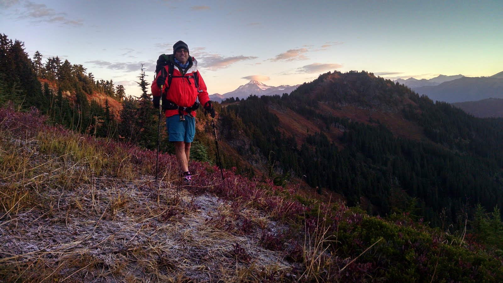
Back on the Trail, Again
(Day 163, Sept 22nd, Leaving Stevens Pass: Mile 2461.6 to Mile 2475.3, hiked 13.7 miles)
We actually made it back to Stevens Pass at a reasonable hour (after spending the night in Leavenworth, WA) but I was still thirsty and Trail Angel George was obliging so we drank some beer in the parking lot. We were reluctant to saddle up our resupplied packs for the next seven-day slog and we watched all the other happy hikers returning to the trail and leaving before us. The weather was sunny and warm and good for hiking (and good for sitting in the parking lot drinking beer). We heard rumors of rain in the forecast but we would have to gamble.
We had a nice day of hiking but someone passed us late in the day and snagged the campsite we had planned for. It was quite surprising how busy the trail still was in September toward the end of our hike and the end of the hiking season. Due to the difficult terrain, there were also fewer and far-between spots to choose from. We weren't expecting the competition for good campsites this late in the hiking season! Nevertheless, we found a nice little spot for the night.
We had a nice day of hiking but someone passed us late in the day and snagged the campsite we had planned for. It was quite surprising how busy the trail still was in September toward the end of our hike and the end of the hiking season. Due to the difficult terrain, there were also fewer and far-between spots to choose from. We weren't expecting the competition for good campsites this late in the hiking season! Nevertheless, we found a nice little spot for the night.
 |
| Perfectly fine camping, if you don't mind losing your fuel and your sunglasses. I slept great. |
This is where the wheels started to come off. The first night of the 7-day stretch my cook stove malfunctioned. My flame wouldn't work correctly and I fiddled with the stove for a bit before giving up and letting Starboard boil water for my meal. Not a problem. Except as an engineer I'm never satisfied with just declaring the stove broken and moving on. Oh no.
(Day 164, Sept 23rd. Mile 2475.3-2495.7, hiked 20.4 miles)
So I decided to try the stove again in the morning for coffee. Success! Or so I thought. Instead, after boiling water and turning off the stove, I left the stove and fuel canister connected and somehow most of the canister emptied itself!! Being tired and groggy I didn't realize what happened until I was packing up the stove. The canister felt both cold and light. It should still have been almost completely full. I compared weight with Robin's still full canister and mine was definitely lighter. Somehow a lot of my fuel had leaked out while I was drinking coffee. Bummer!
This was only day two and now we were already thinking about fuel conservation since I might be out of fuel! Still, we talked through our options and we felt confident that by skimping on our fuel use we would be fine.
 |
| Crisp but pretty, Henry M Jackson Wilderness |
And that's the campsite where Robin left her sunglasses. D'oh!! So maybe not our best campsite after all.....
We set off to hiking in the chilly morning with our morning business chores still to be done with. And then disaster struck again! After more than 2400 miles of faithful almost daily service, the terrain proved too tough for Starboard's digging trowel and it snapped! Man oh man.....
And then Starboard's knee started hurting. This was a pain she's been battling for years. Yet, she had been pain free for 2400 miles! And now it starts hurting? What the f**cats?? This really was a desperate problem. We were carrying an ace bandage and some high-octane pain killers just in case. But we're also only one day away from a major highway. We could walk back out. But that's backwards to Highway 2. Or, alternatively, we still have 6 days of hiking to make it to Rainy Pass for our next resupply. Should we turn around now and rest Robin's knee? Or should we limp it along and hike at a slower pace for a few days to see how she feels? Also, I just wasted (lost) a bunch of fuel. And the weather forecast isn't totally awesome either.
We looked at the maps and the Yogi guide and decide that since there is a decent hiker bail-out trail a few days away we should keep going. But the pain and agony for Starboard becomes very frustrating.
We quickly deploy the ace bandage for starters. We consider stopping early for the day and just resting in the sun to give her knee a break. In the end, we keep on hiking just like every day since crossing the Columbia River. She's a mule!
A few miles into our morning we meet a hiker heading the other way. He's a hiker we met the day before at Stevens Pass, hiking North just like us. We're all confused. We ask him if he was Southbound? He asks us if we turned around and were Southbounding for some reason? But he was hiking faster than us yesterday and was supposed to be ahead of us somewhere this morning. How could we have passed him? We did some map consulting and it turns out he had been hiking South for about 30 minutes for the start of his day! Whoops! Everybody laughed and headed North again together. (We heard lots of these stories about hikers getting back on trail and inadvertently walking in the wrong direction. Sometimes for hours. Hilarious, though disheartening.)
The hiking and the weather was decent and Robin suffered admirably along. This was actually one of the more challenging sections. It's approximately 127 miles from highway 2 at Steven's Pass to highway 20 at Rainy Pass. It's quite remote. Stehekin is approximately 107 miles north of highway 2. And that's pretty much it. There's a trail or two where you can walk out to another road to somewhere. But even those 'outs' are about 8 or so miles from the PCT trail. And once at the trailhead, you still have to find a ride to a town.
Also, the elevation profile is quite challenging. According to Halfmile, this 127 mile section involves approximately 31,800' of up hiking and 31,015' of down walking. That's a lot of up and down! Yes, it was steep at times!
We camped in a cold little saddle near the Indian Creek trail junction. It was pretty damp and cold strangely. Luckily it still wasn't raining and we had a decent day of hiking in overcast weather. This is the day we would meet the trail junction to the North Fork of the Sauk river. This was our chance to bail out and rest for a few days if Robin really couldn't walk on her knee anymore. The weather was definitely changing for the worse. We had about 4 miles to hike to make our choice.
(Day 165, Sept 24th. Mile 2495.7-2515.3; hiked 19.6 miles)
There was never really a choice. Starboard had no intention of stopping. And I'm glad we kept going. Logistically, it would have been difficult to hike out to the road and then have to hike back in another 8 miles or more just to rejoin the trail. Better to just slog on through and hope for the best!
We were concerned about moving slowly though. And we had somehow misjudged our distance from Highway 2. We somehow missed 10 miles and 10,000 feet of elevation change when we made our tentative schedule. So now, not only were we running low on fuel, we had an extra 10 miles to hike we hadn't accounted for. This would change our eta to Rainy pass a little bit. So now we were worried that Starboard's father would be worried about us not showing up on time at the Rainy pass trailhead where he was meeting us with our final resupply.
We got lucky and met a great local hiker just about where the trail junction for the bailout point was. (This was also right about at the 2500 mile marker.) We discussed our problems and finally decided to send a message with the local hiker who was hiking back out to civilization. She offered to call Starboard's parents and brother to try and relay the message that we would be late to Rainy Pass, but not to worry about us. We even tried to convey the plan that Starboard's family could maybe drive a car and leave it at the trailhead for us for whenever we would show up, giving details about where to leave the keys and everything.
We had been rationing our fuel and sharing a stove, so we were pretty confident that our food and fuel would be enough to make it to Rainy Pass regardless. Besides, what's a day or so of cold food and hunger after 2500 miles?
We met a few hikers to take pictures for the 2500 mile marker and followed them all down the trail. The weather was still decent, though threatening to rain or snow. Starboard was still going strong despite the knee pain.
We found a great campsite in a small cirque near Fire creek and were surprised to have it to ourselves after seeing so many hikers. We wanted to make it up over the next pass but we were tired and it was just too far. It was almost dark when we set up our tent anyway. We did see a few headlamps and heard some other hikers pass us by after we were in the tent anyway.
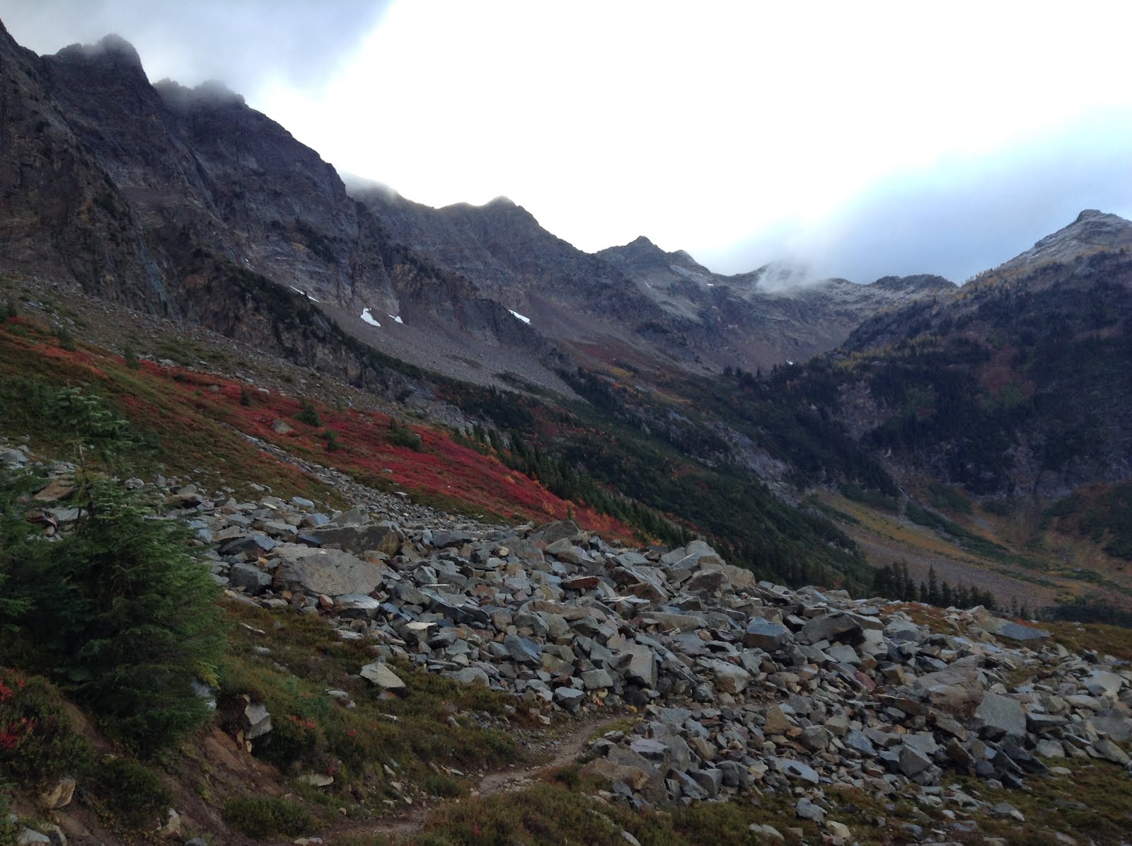
Then the trail started to deteriorate. And how. I would say this section, from approximately mile 2510 to 2532 were the most difficult hiking along the entire trail. Not kidding. There were a few reasons for this. First, the trail appeared to have been all but abandoned. Lots of logs across the trail. Lots of trail washouts. Lots of overgrowth in the trail. There had been almost no trail maintenance here it seemed. Then, it started raining. And boy did it rain. It's a good thing we had our rain pants! Also, this section was really steep. This is one of the more remote sections that goes around the west side of Glacier Peak.
It turns out, this section has been abandoned! Not intentionally, but two or three major storms since 2003 have made it difficult to do trail maintenance on this remote section.
Check out this write-up about the trail from the PCTA.
http://www.pcta.org/2015/glacier-peak-wilderness-finally-ready-for-project-planning-35623/
Considering the challenge to repair, we were lucky to have trail at all!
(Day 166, Sept 25th. Mile 2515.3-2532.7; hiked 17.4 miles in the rain)
Did I mention the trail was steep? According to Halfmile, the difficult 17-mile day from Fire creek to Vista creek we hiked uphill 5400' and downhill 7065' ! Did I also mention that the downhill hiking is what really hurts Robin's knee? This was the day Starboard needed a little extra boost to her Ibuprofen dose. Modern medicine is amazing. She was a much happier hiker when she was pain free.
The next night we camped at Vista creek and immediately the trail improved. It was like night and day how much nicer the trail was.
(Day 167, Sept 26th. Mile 2532.7 - 2554.6; hiked 21.9 miles)
This was clearly the latest stopping point of the trail maintenance crew. It's amazing how much our pace quickened by the expertly repaired trail. And the bridge over the Suiattle river was amazing. In fact, we had a rare patch of sunshine on the bridge, and I stayed an extra 45 minutes after Starboard left from our morning break to let the tent dry out in the patch of sun. Wise decision too, as we had another cold damp night after hiking through some snow over Suiattle Pass.
And we met Pistol Pete the Porcupine. Followed him down the trail for almost thirty minutes too. He didn't really like us hiking behind him, and everytime we would get a little too close he would speed up and waddle down the trial. Let me just say that's it's hilarious watching a porcupine try to run down the trail! At one point, we decided we should go off trail and try to get ahead of the slow moving beast. But he was way smarter than us and cut the switchback first! Danggit! Then we saw an opportunity to get ahead again if we went cross-country to the trail. So off we went, scrambling through the wet brush and rocks. Just before we made it back onto the trail, there goes Pete, ambling by ahead of us! Danggit again! That guy was way smarter than we were and we resigned ourselves to being stuck behind him for as long as he stayed on the trail. We didn't want to get stickered by his quills!
Luckily, he finally got tired of us following and he wandered off the trail and up into the moraine rocks.
(Day 168, Sept 27th Mile 2554.6-2574.3; hiked 19.7 miles)
Cold in the morning, but another pretty day. We somehow found a wallet on the trail. We would not have seen it, but it was sitting on a log in an established campsite and it was lunchtime so we stopped to get water and eat lunch. After rummaging through the wallet we determined it was nobody we knew. We decided to carry it because even if we never found the owner, leaving it in the middle of nowhere in the wilderness didn't seem like a great option. Also, the ID showed a Seattle address and we guessed that at the very minimum we might be able to deliver it home after we finished the trail.
There's a funny little conundrum in the North Cascades National Park. You are required to have a permit to camp in the park. This is nothing new to us as we spend lots of time in National parks. As PCT thru-hikers, we sadly see a lot of hikers who feel entitled to do whatever they want because of the scope of their adventure. So getting an extra permit to camp in the Park can be seen as a burden. Yet, the PCT long distance permit covers most of the permitted areas of the trail. It does not cover this park though. So a PCT hiker must leave the trail and go into Stehekin to the Ranger station to obtain a permit.
Here's the problem with that. From the South Boundary of North Cascades National Park to the North Boundary of the park is 16 miles. Stehekin is near the South boundary. If you go into Stehekin, you are likely to stay the night there as it's a good place to stop, rest and resupply. At this point, most hikers can easily hike more than 16 miles in a day. Probably more like 20-25 miles. So if you want to skip Stehekin (like we did), you want to hike past Stehekin and possibly camp in the park. But logistically it might not make sense to camp at the south boundary (Stehekin basically) and then hike through the park. Likely, you'll end up in the middle of the park somewhere and be wanting to camp. Say, you might be at your 22 miles for the day, but only around mile six of the park's 16 miles. So you would have to go into Stehekin to get a camping permit. But to go into Stehekin, you would have to catch the bus. This would cost time and money. Like, hours of time. The bus only runs a few times during the day. And the ranger station is only open for limited hours. So catching the right bus to get to the ranger station and catching another bus back to the trail might be very difficult. And if you're in town anyway, you might as well camp there. And then you wouldn't need a camping permit because you'd walk through the park the next day! So going into town to get the permit turns out to be quite a burden for the PCT thru-hiker. Anyway, petty thru-hiker problems. We always try to do the right thing and follow the rules. And we're more than happy to give the National Parks our money. We were a little bummed out that this one small section was such a logistical burden to follow the rules. I realize how busy this park is in the summer and I hope we didn't displace any other hopeful campers! (we had the place to ourselves....)
(Day 169, Sept 28th, Mile 2574.3 - 2588.9, hiked 14.6 miles, Happy Birthday Mom!)
And great news! Starboard's family indeed got the message about us possibly being late to the trailhead. Luckily, Starboard's dad was smart enough to ignore our suggestions and decided to just wait for us at the trailhead, no matter if we were 12 or 24 hours late. He met us at the trailhead with cold beer and our travel van ready to take us to Winthrop for KOA camping - a real step-up for us trail trash!! woohoo!
The hiking and the weather was decent and Robin suffered admirably along. This was actually one of the more challenging sections. It's approximately 127 miles from highway 2 at Steven's Pass to highway 20 at Rainy Pass. It's quite remote. Stehekin is approximately 107 miles north of highway 2. And that's pretty much it. There's a trail or two where you can walk out to another road to somewhere. But even those 'outs' are about 8 or so miles from the PCT trail. And once at the trailhead, you still have to find a ride to a town.
Also, the elevation profile is quite challenging. According to Halfmile, this 127 mile section involves approximately 31,800' of up hiking and 31,015' of down walking. That's a lot of up and down! Yes, it was steep at times!
We camped in a cold little saddle near the Indian Creek trail junction. It was pretty damp and cold strangely. Luckily it still wasn't raining and we had a decent day of hiking in overcast weather. This is the day we would meet the trail junction to the North Fork of the Sauk river. This was our chance to bail out and rest for a few days if Robin really couldn't walk on her knee anymore. The weather was definitely changing for the worse. We had about 4 miles to hike to make our choice.
 |
| Glacier Peaks Wilderness near Indian Pass |
(Day 165, Sept 24th. Mile 2495.7-2515.3; hiked 19.6 miles)
There was never really a choice. Starboard had no intention of stopping. And I'm glad we kept going. Logistically, it would have been difficult to hike out to the road and then have to hike back in another 8 miles or more just to rejoin the trail. Better to just slog on through and hope for the best!
We were concerned about moving slowly though. And we had somehow misjudged our distance from Highway 2. We somehow missed 10 miles and 10,000 feet of elevation change when we made our tentative schedule. So now, not only were we running low on fuel, we had an extra 10 miles to hike we hadn't accounted for. This would change our eta to Rainy pass a little bit. So now we were worried that Starboard's father would be worried about us not showing up on time at the Rainy pass trailhead where he was meeting us with our final resupply.
 |
| Ahhhh,......Washington |
We got lucky and met a great local hiker just about where the trail junction for the bailout point was. (This was also right about at the 2500 mile marker.) We discussed our problems and finally decided to send a message with the local hiker who was hiking back out to civilization. She offered to call Starboard's parents and brother to try and relay the message that we would be late to Rainy Pass, but not to worry about us. We even tried to convey the plan that Starboard's family could maybe drive a car and leave it at the trailhead for us for whenever we would show up, giving details about where to leave the keys and everything.
We had been rationing our fuel and sharing a stove, so we were pretty confident that our food and fuel would be enough to make it to Rainy Pass regardless. Besides, what's a day or so of cold food and hunger after 2500 miles?
We met a few hikers to take pictures for the 2500 mile marker and followed them all down the trail. The weather was still decent, though threatening to rain or snow. Starboard was still going strong despite the knee pain.
We found a great campsite in a small cirque near Fire creek and were surprised to have it to ourselves after seeing so many hikers. We wanted to make it up over the next pass but we were tired and it was just too far. It was almost dark when we set up our tent anyway. We did see a few headlamps and heard some other hikers pass us by after we were in the tent anyway.
 |
| And the wheels are coming off...broken trowel, bad knee, cold weather. |
 |
| Still together after 2500... |
 |
| See? I told you the first 2500 miles would be worth it!! |
Then the trail started to deteriorate. And how. I would say this section, from approximately mile 2510 to 2532 were the most difficult hiking along the entire trail. Not kidding. There were a few reasons for this. First, the trail appeared to have been all but abandoned. Lots of logs across the trail. Lots of trail washouts. Lots of overgrowth in the trail. There had been almost no trail maintenance here it seemed. Then, it started raining. And boy did it rain. It's a good thing we had our rain pants! Also, this section was really steep. This is one of the more remote sections that goes around the west side of Glacier Peak.
It turns out, this section has been abandoned! Not intentionally, but two or three major storms since 2003 have made it difficult to do trail maintenance on this remote section.
Check out this write-up about the trail from the PCTA.
http://www.pcta.org/2015/glacier-peak-wilderness-finally-ready-for-project-planning-35623/
Considering the challenge to repair, we were lucky to have trail at all!
 |
| One of the easier log crossings - good thing we're short! |
 |
| Kennedy Creek? This was one of the better spots.... |
(Day 166, Sept 25th. Mile 2515.3-2532.7; hiked 17.4 miles in the rain)
Did I mention the trail was steep? According to Halfmile, the difficult 17-mile day from Fire creek to Vista creek we hiked uphill 5400' and downhill 7065' ! Did I also mention that the downhill hiking is what really hurts Robin's knee? This was the day Starboard needed a little extra boost to her Ibuprofen dose. Modern medicine is amazing. She was a much happier hiker when she was pain free.
 | |
| Enjoying the rain on Fire Creek Pass |
 |
| Dropping down from Fire Creek Pass toward Mica Lake |
 |
| Enjoying the view at Milk Creek |
 |
| Tra la la la la-ing in the rain, descending to Vista Creek |
The next night we camped at Vista creek and immediately the trail improved. It was like night and day how much nicer the trail was.
(Day 167, Sept 26th. Mile 2532.7 - 2554.6; hiked 21.9 miles)
This was clearly the latest stopping point of the trail maintenance crew. It's amazing how much our pace quickened by the expertly repaired trail. And the bridge over the Suiattle river was amazing. In fact, we had a rare patch of sunshine on the bridge, and I stayed an extra 45 minutes after Starboard left from our morning break to let the tent dry out in the patch of sun. Wise decision too, as we had another cold damp night after hiking through some snow over Suiattle Pass.
 |
| Drying out the tent, Suiattle River Bridge PCT |
 |
| North of Suiattle Pass |
And we met Pistol Pete the Porcupine. Followed him down the trail for almost thirty minutes too. He didn't really like us hiking behind him, and everytime we would get a little too close he would speed up and waddle down the trial. Let me just say that's it's hilarious watching a porcupine try to run down the trail! At one point, we decided we should go off trail and try to get ahead of the slow moving beast. But he was way smarter than us and cut the switchback first! Danggit! Then we saw an opportunity to get ahead again if we went cross-country to the trail. So off we went, scrambling through the wet brush and rocks. Just before we made it back onto the trail, there goes Pete, ambling by ahead of us! Danggit again! That guy was way smarter than we were and we resigned ourselves to being stuck behind him for as long as he stayed on the trail. We didn't want to get stickered by his quills!
Luckily, he finally got tired of us following and he wandered off the trail and up into the moraine rocks.
 | |
| Chasin' Pistol Pete the Porcupine |
(Day 168, Sept 27th Mile 2554.6-2574.3; hiked 19.7 miles)
Cold in the morning, but another pretty day. We somehow found a wallet on the trail. We would not have seen it, but it was sitting on a log in an established campsite and it was lunchtime so we stopped to get water and eat lunch. After rummaging through the wallet we determined it was nobody we knew. We decided to carry it because even if we never found the owner, leaving it in the middle of nowhere in the wilderness didn't seem like a great option. Also, the ID showed a Seattle address and we guessed that at the very minimum we might be able to deliver it home after we finished the trail.
There's a funny little conundrum in the North Cascades National Park. You are required to have a permit to camp in the park. This is nothing new to us as we spend lots of time in National parks. As PCT thru-hikers, we sadly see a lot of hikers who feel entitled to do whatever they want because of the scope of their adventure. So getting an extra permit to camp in the Park can be seen as a burden. Yet, the PCT long distance permit covers most of the permitted areas of the trail. It does not cover this park though. So a PCT hiker must leave the trail and go into Stehekin to the Ranger station to obtain a permit.
Here's the problem with that. From the South Boundary of North Cascades National Park to the North Boundary of the park is 16 miles. Stehekin is near the South boundary. If you go into Stehekin, you are likely to stay the night there as it's a good place to stop, rest and resupply. At this point, most hikers can easily hike more than 16 miles in a day. Probably more like 20-25 miles. So if you want to skip Stehekin (like we did), you want to hike past Stehekin and possibly camp in the park. But logistically it might not make sense to camp at the south boundary (Stehekin basically) and then hike through the park. Likely, you'll end up in the middle of the park somewhere and be wanting to camp. Say, you might be at your 22 miles for the day, but only around mile six of the park's 16 miles. So you would have to go into Stehekin to get a camping permit. But to go into Stehekin, you would have to catch the bus. This would cost time and money. Like, hours of time. The bus only runs a few times during the day. And the ranger station is only open for limited hours. So catching the right bus to get to the ranger station and catching another bus back to the trail might be very difficult. And if you're in town anyway, you might as well camp there. And then you wouldn't need a camping permit because you'd walk through the park the next day! So going into town to get the permit turns out to be quite a burden for the PCT thru-hiker. Anyway, petty thru-hiker problems. We always try to do the right thing and follow the rules. And we're more than happy to give the National Parks our money. We were a little bummed out that this one small section was such a logistical burden to follow the rules. I realize how busy this park is in the summer and I hope we didn't displace any other hopeful campers! (we had the place to ourselves....)
 |
| North Cascades National Park |
And great news! Starboard's family indeed got the message about us possibly being late to the trailhead. Luckily, Starboard's dad was smart enough to ignore our suggestions and decided to just wait for us at the trailhead, no matter if we were 12 or 24 hours late. He met us at the trailhead with cold beer and our travel van ready to take us to Winthrop for KOA camping - a real step-up for us trail trash!! woohoo!
 | |
| Good Time, Starboard and Trail Angel George, Rainy Pass |
 | |
| Enjoying the Van |
We made it! We didn't run out of fuel and Starboard suffered through the pain like a rock star. It was definitely a challenging section of the trail and we determined it was finally time for a day off. Rest the knee. Recharge and relax and psyche ourselves up for the final push to Canada.
Alas, it was not to be. The weather forecast was too good and we couldn't afford to take a day off.......
Alas, it was not to be. The weather forecast was too good and we couldn't afford to take a day off.......
(Just a short note for those of you following along at home - somewhere along the line, our day count was messed up and we fell a day behind the actual count of days on trail. We started April 13th, and so indeed September 28th was our 169th day since starting. There's probably a few numbers that don't match up somewhere in the blog. It's not easy to remember what day it is in the wilderness!)

No comments:
Post a Comment
Keep it clean. Don't be mean.